Sands Of Time... The Truth About Beach Replenishment
There are few subjects in Cape May capable of producing quite as much certainty as beach replenishment. Everybody knows what went wrong. The Army Corps ruined the beach, right? Today’s sand is too coarse. The beach is too wide. The slope into the ocean is too steep. They should leave it alone. Or maybe they should put more sand on it. Or less sand on it. The old beach was much better.
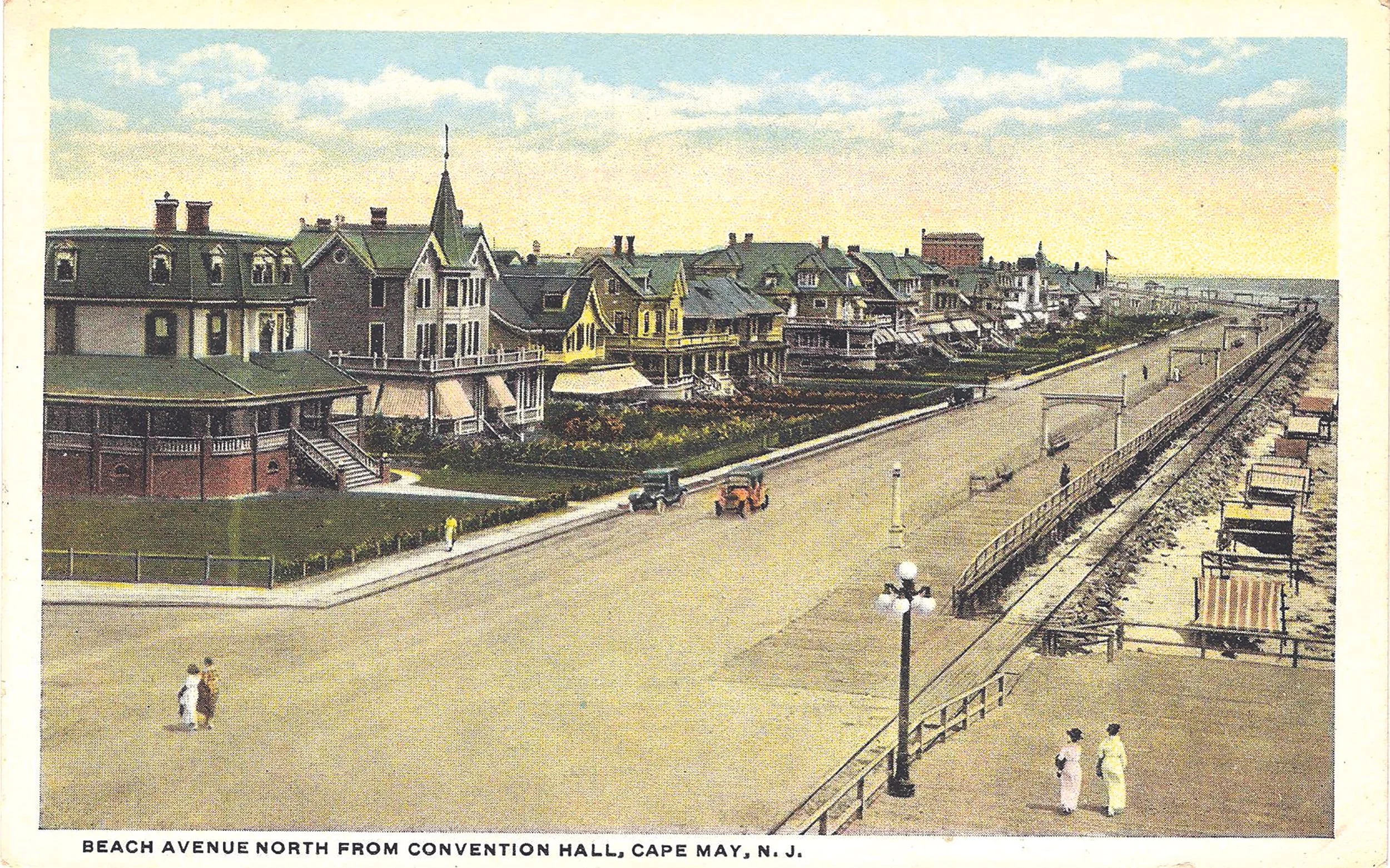
The old beach, according to some, seems to have been perfect. It was narrower and softer, the ocean was closer to the promenade, the waves were friendlier and you didn’t need to pack provisions for the walk from your beach box to the water. I have a great deal of sympathy for this view. Cape May is a town built partly on nostalgia, and I am as susceptible to it as anyone.
But memory is a wonderful thing and a lousy surveying instrument. Because the first thing you discover when you start digging into the history of Cape May’s beaches is that there never was a normal beach. Not for very long, anyway. The shoreline has been moving, shrinking, growing, shifting and getting clobbered by the Atlantic since long before anybody thought of pumping sand onto it.
And this is where we meet C.F. Wicker, a man I had never heard of until I did some serious digging into the sand...
Wicker was chief of the Engineering Division of the Philadelphia District of the Army Corps of Engineers. In 1950, he published a remarkably detailed paper called “History of New Jersey Coastline”, in which he reconstructed changes to our shoreline using surveys dating to 1842 and other evidence stretching back even further. This was 41 years before Cape May’s modern beach-replenishment program began, so Wicker was not trying to defend the vast beaches we have today. He was simply trying to understand what the coastline had been doing.
What he found rather complicates the easy version of this story.
From 1842 to 1899, Wicker calculated that Cape May’s beaches retreated at an average rate of about 4.1 feet per year. From 1899 to 1948, the rate was about 4.2 feet per year. In other words, Cape May had a significant erosion problem even before the federal government built the inlet jetties.
That second period, however, included one of the most consequential pieces of engineering ever undertaken around Cape May.
Beginning in the early 1900s, the Pittsburgh-backed developers dreaming of a new East Cape May excavated an enormous harbor from the marshes behind town. But there was an obvious problem. A magnificent new harbor wasn’t much use unless ships could reliably get from the Atlantic into it.
So Congress stepped in. In 1907 it authorized the Army Corps of Engineers to improve Cold Spring Inlet, as Cape May Inlet was then known. Between 1908 and 1911, the Corps dredged a navigation channel and built two immense parallel stone jetties, each extending more than 4,000 feet into the ocean. Their job was straightforward: stabilize the inlet, keep shifting sand from repeatedly clogging the channel and create a dependable entrance to the new harbor.
They succeeded. They also changed what the sand was doing.
Wicker found that in the early years after the jetties were built, sand began accumulating against the eastern jetty at a rate of roughly 100,000 cubic yards a year. That sand would otherwise have continued moving along the coast toward us. As Wicker explained it, the beaches to the west — including Cape May — were being deprived of roughly the same amount of natural nourishment.
Which sounds, at first, like we have found our culprit. Not so fast, though.
While the jetties were trapping sand, the Corps was also dredging the harbor and navigation channel — and about 1.3 million cubic yards of that dredged material was placed on beaches west of the inlet. In other words, the same federal project that was interfering with Cape May’s natural supply of sand was simultaneously putting enormous amounts of sand back onto the beach.
Wicker’s larger point was that trying to blame Cape May’s shoreline changes on one cause was hopeless. He described the coastline as being governed by what he called a “symphony of forces”: waves, currents, tides, wind, storms, inlets, jetties, groins and, underlying all of them, the amount of sand actually available to be pushed around.
Think of the beach as a bank account. Storms make big withdrawals. Ordinary waves move sand around. Currents transfer it down the coast. Inlets siphon some away. Groins hold some in one place while reducing the amount moving farther along. Jetties interfere with the transfers. And there isn’t an unlimited new supply of sand arriving every Friday.
Wicker believed that was one of the fundamental problems along the New Jersey coast: much of the sand was simply being redistributed rather than constantly replaced by some inexhaustible natural source.
Then there are the storms.
If Wicker’s slow average erosion rate sounds relatively benign — four feet here, four feet there — a nor’easter can change the shoreline with breathtaking speed. Storm waves tear into dunes and berms, pull sand from the visible beach and move it offshore or along the coast. Some of that sand may return during calmer conditions. Some will not. The result is that a beach that looked perfectly healthy in August can look radically different after several days of bad weather.
Cape May has had no shortage of demonstrations. The most famous, of course, was the Ash Wednesday Storm of March 1962, one of the most destructive storms ever to hit the Jersey Shore. The Army Corps’ post-storm aerial photographs show beaches stripped away, damaged structures and the Atlantic pushed frighteningly close to developed areas. That was almost 30 years before the modern replenishment program began.
Which is worth remembering when we wax nostalgically about the pre-replenishment beach. People are not wrong when they say it was different. It was narrower. The sand was often finer. The water was closer. Recent research has even found measurable changes in the grain size and character of Cape May’s beach after decades of nourishment.
But the choice was never between preserving that lovely old beach exactly as it was and replacing it with an engineered one.
The old beach was moving, too. Storms were hitting it. Currents were moving it. Tides were working on it. Groins and seawalls were already interfering with it. The inlet jetties had altered the movement of sand from the north.
Plus, over the longer term, rising sea levels have added another pressure by allowing waves and storm surges to operate from a gradually higher starting point.
This is where I think some of the nostalgic folks start to, ahem, bury their heads in the sand (couldn’t help myself).
You can absolutely prefer the old beach. What you cannot reasonably assume is that the beach of 1965, 1975 or 1985 would still be sitting there today if everybody had simply left it alone.
By the late 20th century, erosion had become impossible to ignore. Corps photographs from before the modern project show stretches around Wilmington, Gurney and Baltimore avenues where there was astonishingly little beach left between the Atlantic and the city’s structures. On the Coast Guard side of town, conditions were similarly precarious.
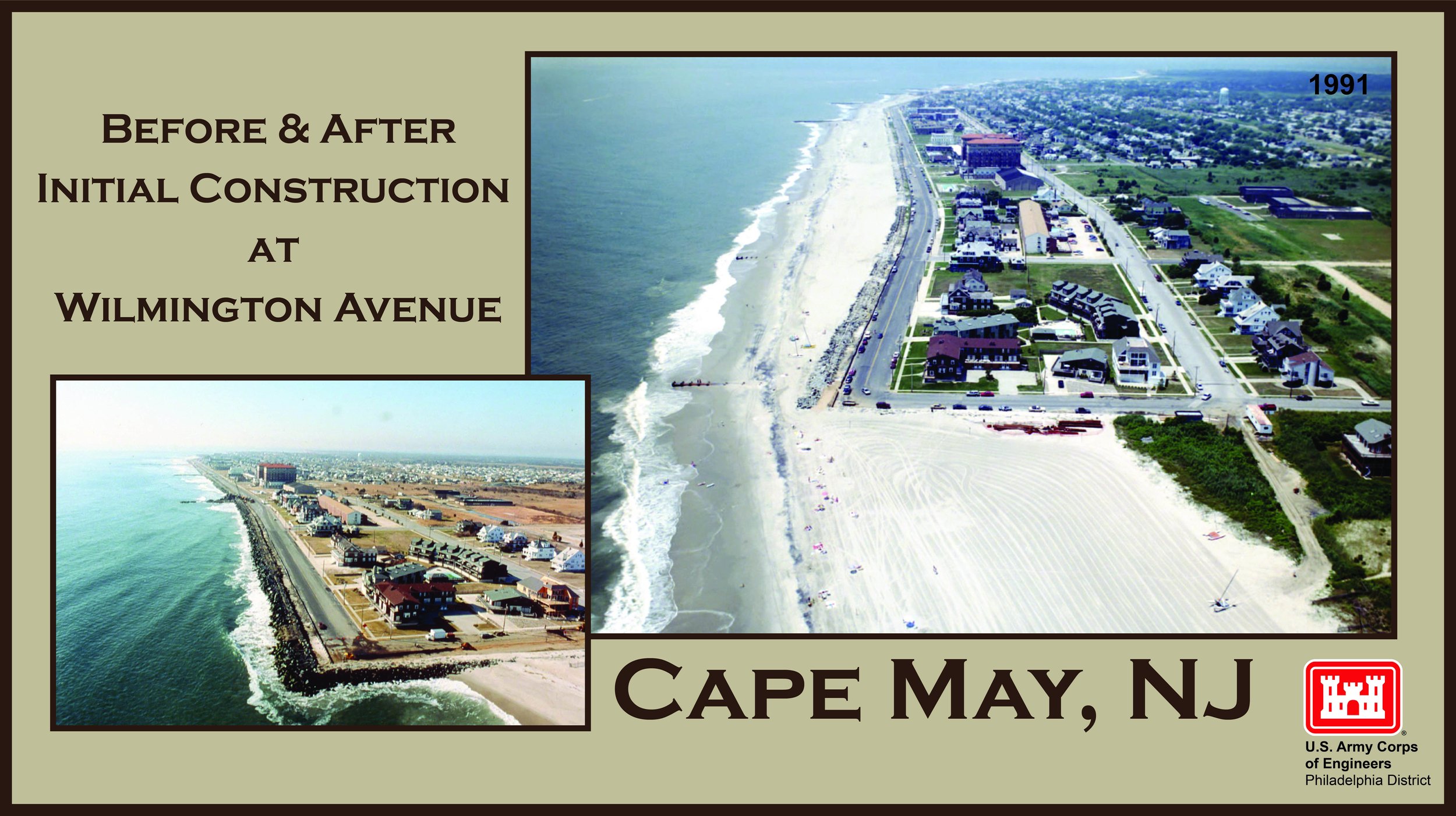
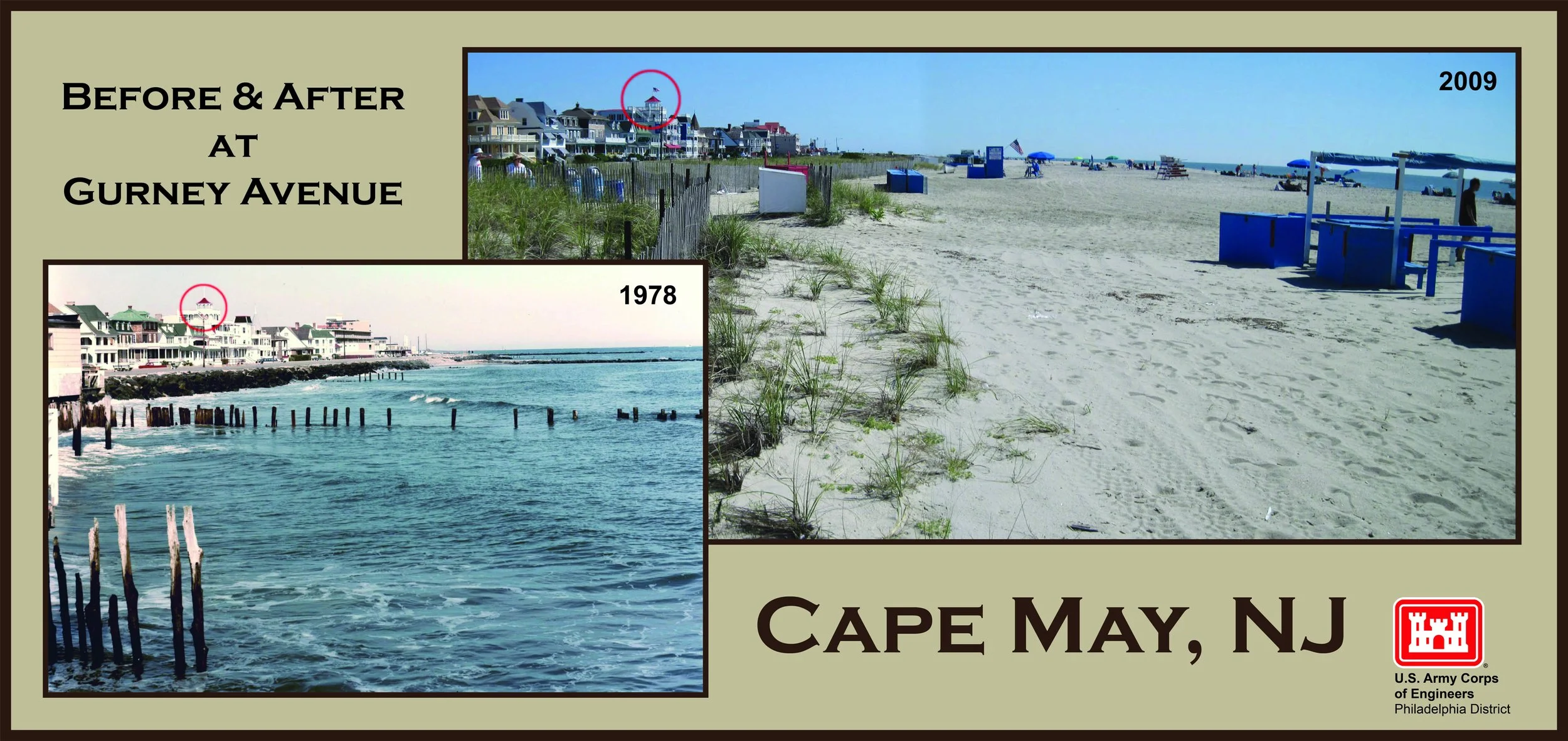
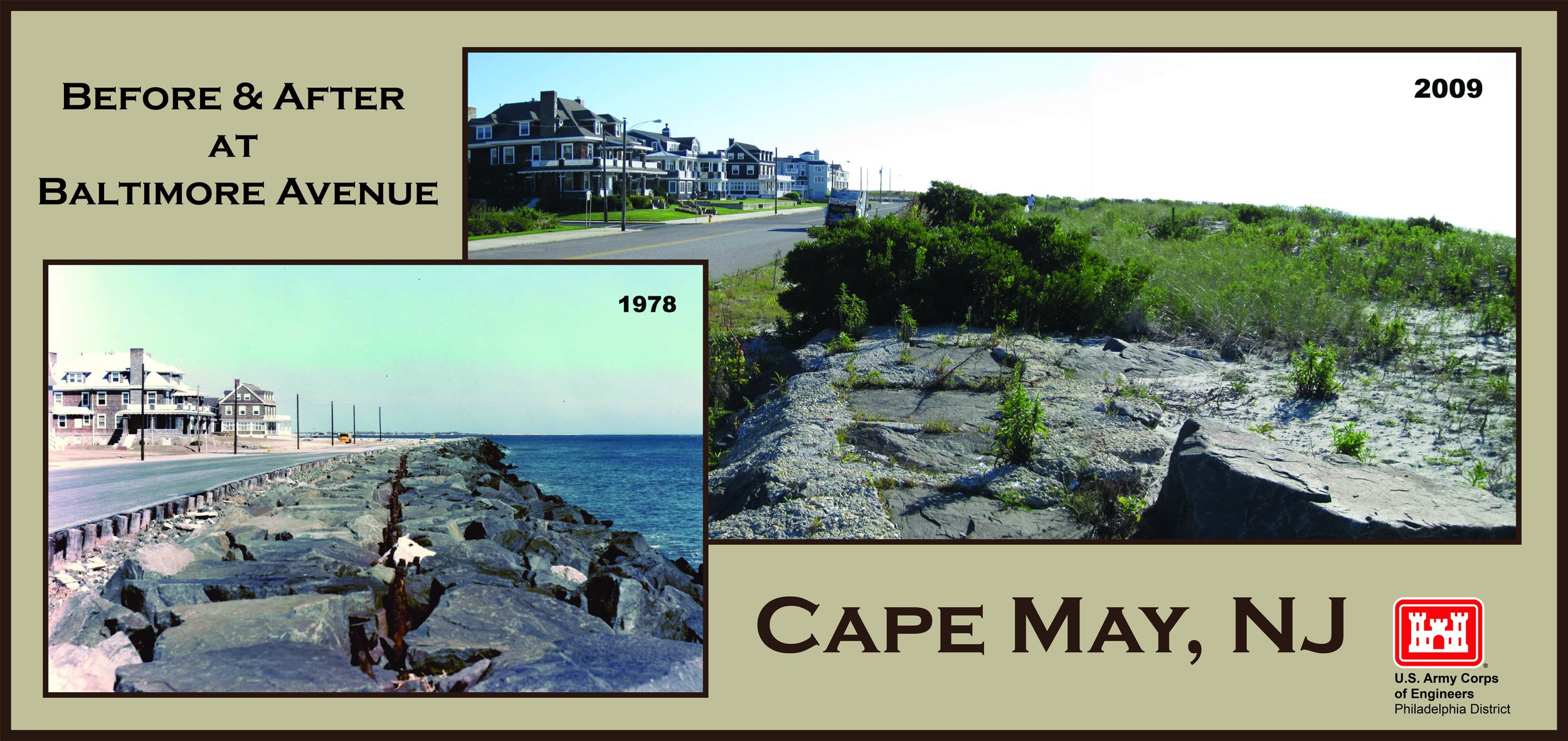
So in 1991, the Cape May Inlet-to-Lower Township shore-protection project began.
The Corps rebuilt the shoreline from Cape May Inlet down to Third Avenue, creating a wide berm of sand, rebuilding or modifying groins and extending stormwater outfalls. The purpose was not to make tourists happy or provide additional acreage for umbrellas. It was coastal storm protection. The beach became the buffer — a large pile of sacrificial sand for waves to attack before they reached Beach Avenue, homes, businesses, utilities and the Coast Guard base.
And because everything Wicker had written about sand still applied, the Corps knew it would have to return.
Again and again.
By the end of 2023, Cape May had undergone its FOURTEENTH nourishment cycle. That latest project called for roughly 517,000 cubic yards of additional sand under a contract worth about $16 million. Some years the beach gets wider, some sections lose sand faster than others, and storms can undo an extraordinary amount of work in short order.
To critics, this can look absurd: millions of dollars spent putting sand onto a beach knowing perfectly well that some of it is going to move away.
But movement does not necessarily mean failure. The beach is supposed to absorb storm energy. Losing sand during a storm can be the coastal equivalent of a car airbag deploying — you don’t complain that the airbag has been ruined. The question is what it prevented from being ruined behind it.
None of this means replenishment is beyond criticism. People have raised legitimate concerns about the coarser sand, changing beach profiles and steep shore breaks. No one did more to force that issue into public view than Cape May native and former lifeguard Chad DeSatnick. In 2001, DeSatnick shattered two vertebrae in his neck while surfing at Poverty Beach and was initially told he might never walk again. He recovered, then spent years pressing city council to take seriously the growing number of neck and spinal injuries associated with Cape May’s punishing shore break.
It was not a quick victory. Chad kept showing up, gathering allies in the beach patrol and fire department and pushing for public education until, by 2009, the city was distributing beach-safety brochures with beach tags and posting shore-break warning signs at beach entrances. His campaign eventually helped turn beach safety from a subject Cape May could wave away into an official city concern, complete with a Beach Safety Advisory Committee examining beach slope and possible engineering changes.
And then there is the deliciously strange case of Wildwood.
For years, people in Cape May have repeated a version of the story in which all of our missing sand somehow ended up there. That is too simplistic, but the connection between the two places is real. The Cape May inlet structures altered the natural movement of sand, while the later closing of Turtle Gut Inlet farther north changed things again. Over time, enormous amounts of sand accumulated along parts of Wildwood and Wildwood Crest.
The result is visible to anyone who has attempted the expedition from the Wildwood boardwalk to the ocean. When I first saw those beaches, I joked that someone should start a water taxi service. Later, someone actually did. In places, the distance can amount to several football fields. Meanwhile, North Wildwood has the opposite problem, experiencing severe erosion.
Cape May County has somehow ended up with too much sand in one place and not enough a few miles away. Engineers now talk about “backpassing” sand — mechanically moving excess sand from one part of the Wildwoods to another.
We don’t have a shortage of sand so much as a sand-distribution problem.
Which brings us to the future.
The Army Corps’ current documents list the Cape May project as continuing through 2039, based on the long-term partnership arrangement that began in 1991. But there is an important caveat: individual nourishment cycles still depend on federal funding. The words the Corps uses are “pending funding.”
So 2039 is not a giant prepaid contract guaranteeing that a dredge will appear every two years regardless of what happens in Washington. It is the planned life of the federal project. Congress and the administration still have to provide money for individual rounds of work.
After all of this digging, I keep coming back to Wicker. Long before modern beach replenishment, before the Ash Wednesday Storm, before anyone was arguing on Facebook about beach slopes, he had already figured out the central problem.
There was no single Cape May beach.
There was a shoreline being continually negotiated by waves, currents, tides, storms, inlets, jetties, groins and a finite supply of sand. Since then we have added dredges, bulldozers, millions of federal dollars and rising seas to Wicker’s “symphony of forces.”
The Army Corps did not invent erosion in Cape May. Nature had been managing that perfectly well for centuries. But humans altered the system, too, first by stabilizing an inlet and building a city along a shoreline that was never interested in staying put, and later by deciding that we were not prepared to surrender that city to the Atlantic.
We want the narrower, softer beach we remember. We also want the promenade, the hotels, the Victorian houses, Beach Avenue and the Coast Guard base to remain approximately where we put them.
Nature, however, has never offered that particular package.