
The Short And Stormy Life Of South Cape May
Walk the paths through South Cape May Meadows on a clear morning — past the freshwater ponds, beneath the lighthouse, and eventually over the dunes to a protected mile of beach — and it is easy to believe the land has always belonged to the birds. The Nature Conservancy’s preserve now offers just over two miles of trails, including a half-mile accessible boardwalk installed in 2024, along with an observation platform and an 80-foot bird blind. It is calm, open and remarkably undeveloped, which on the Jersey Shore can feel less like a rural landscape and more like an administrative oversight.
The stillness is deceptive, though. Much of what is now meadow, wetland and dune once formed the Borough of South Cape May, a separate municipality with its own mayor, council and clerk, rather than a neighborhood governed by the City of Cape May. Streets crossed the land in a strict grid; trolley cars ran beside the beach; hotels and cottages welcomed summer guests. For generations, people looked at this exposed piece of Cape Island and saw the next big seaside resort. The ocean, on the other hand, with a consistency the developers never quite managed, kept seeing something else.
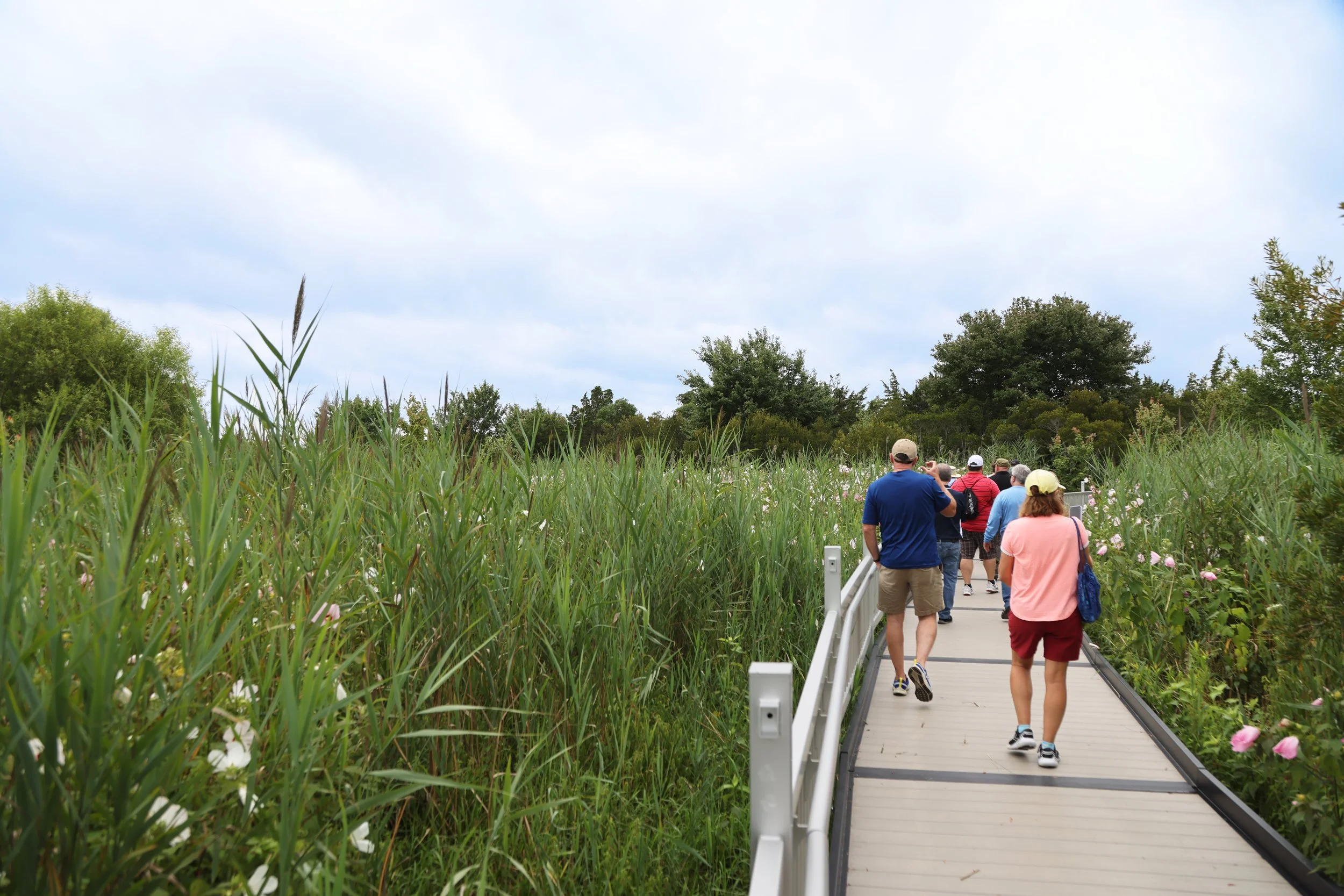
South Cape Meadows Trail
The first grand attempt came before the borough officially existed. In 1852, Philadelphia investors began building the Mount Vernon Hotel adjacent to what would become South Cape May. It was promoted as the largest hotel in the world, with plans for roughly 1,200 rooms and 3,000 guests; the dining room alone was said to be 425 feet long and lit by 40 gas chandeliers. The project never reached the scale promised, and in September 1856 the vast wooden building burned, killing six people and taking an estimated fortune with it.
By the early 1880s, Theodore M. Reger and his associates were trying again. Victorian developers did not have Instagram, but they understood spectacle, so they erected a wooden elephant near the beach. The Light of Asia, begun in 1884 and completed the following year, belonged to the same family-of-three that included Lucy the Elephant in Margate. Lucy is the sole survivor (the third member had a short life in Coney Island, NY); her Cape May relative stood more than 58 feet to the top of its howdah (just a fancy word for a platform), with stairs in its hind legs, windows in its eyes and an observation platform on its back.
The elephant served as a real estate office, concession attraction and elevated advertisement. Visitors could buy refreshments, climb up for the view and contemplate purchasing a 30-by-100-foot seaside lot. Promoters claimed it contained nearly a million pieces of wood and 250 kegs of nails, which was perhaps excessive for an office but entirely reasonable for an elephant. Locals called it Jumbo. By the late 1890s its legs were sinking and the structure was deteriorating; it was demolished in 1900, while Lucy from Margate went on to enjoy the sort of long retirement denied to most wooden elephants.
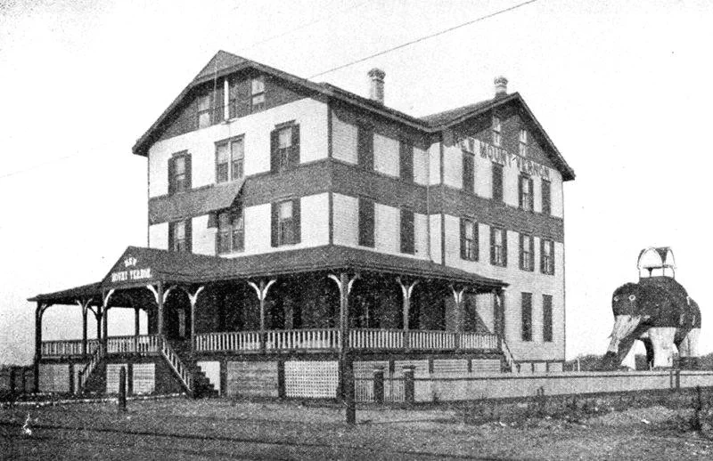
The New Mount Vernon Hotel was built in South Cape May in 1887, a modest tribute to the gigantic Mount Vernon Hotel that burned in 1856. Next to it is the famous Light of Asia elephant.
South Cape May became an independent borough on August 27, 1894, after voters approved its separation from Lower Township. On paper, about 2,500 lots were laid out between Cape May and Cape May Point. On the ground, the difference between ambition and occupancy remained considerable. A newspaper counted 284 people there during the summer of 1892, including 98 hotel guests; the federal census of May 1900 found only 14 permanent residents. Sanborn maps suggest the borough never contained much more than 40 or 50 buildings at one time.
It was small, but it was real. Electricity arrived in 1903, initially only between 8pm and midnight during the summer. Telephone wiring followed in 1911 and household water in 1916. In the busy months, the electric trolley ran along the beach between Cape May and Cape May Point, reportedly every 20 minutes. Joseph Burcher, whose family spent summers there and who later wrote a thorough history of the town (Remembering South Cape May), remembered wool bathing suits, fishing for porgies, buying ice from a wagon and watching rum-runners race trucks onto the beach during Prohibition. During the Second World War, an uncovered upstairs light brought the Coast Guard pounding on the family’s door.
The difficulty was that the town’s most important piece of infrastructure — the beach — kept moving. An unfinished house was blown from its foundation in 1891. Storms in 1903 damaged cottages and washed roughly 2,000 feet of trolley track from its supports. By 1910, beachfront homes were being turned and moved inland behind the tracks. After the winter of 1917–18 destroyed the bulkhead around the Bailie House, the building was hauled inland on immense wooden rollers, reportedly using oxen; it survives today at 12 South Broadway.
By the 1920s, parts of South Cape May already had the air of a place being vacated. A 1923 tax sale listed hundreds of delinquent lots, and a Philadelphia newspaper later ran a story titled “Ghost on the Beach,” in which a nighttime walker approached a dark house and saw a mysterious figure at the window. The “ghost” turned out to be a living woman, but it made for a spookily fun article.
In September 1936, a severe nor’easter flooded Mount Vernon Avenue and destroyed several houses, including the home of South Cape May Mayor Harvey Mentzer, who had spent years pressing for shoreline protection, only to watch the sea remove his own address before the defenses arrived.
The Great Atlantic Hurricane of September 14, 1944 delivered the blow from which the borough did not recover. Water crossed the meadows to Sunset Boulevard, Cape May Point was temporarily cut off, and houses already weakened by erosion were wrecked or left uninhabitable. South Cape May did not literally vanish in one afternoon — a few structures lingered — but its tax base and practical future were gone. On April 30, 1945, the borough was dissolved and its remaining dry land returned to Lower Township.
Even then, the sea had not finished editing. The storm of November 1950 flooded Sunset Boulevard and destroyed or displaced more cottages. In one Burcher family recollection, a small house floated toward the ocean “like a box,” only to return on the incoming tide. The disappearance of South Cape May was not one cinematic wave but a long, untidy retreat, interrupted by people salvaging boards, bricks and whatever else the marsh had not claimed.
Some residents had moved their houses before the worst arrived. As many as 16 buildings were hauled into Cape May City and nearby communities, and researchers have identified 13 that remain occupied. They stand along First Avenue, Second Avenue and South Broadway, among other locations, looking perfectly settled despite having begun life in a municipality that no longer exists. By the mid-1950s, the former borough had become pasture, where Black Angus cattle occasionally wandered onto Sunset Boulevard — another use nobody had included in the original prospectus.
Yet the development instinct had not disappeared, and the most extraordinary evidence survives in hand-drawn plans for a resort called Smugglers Cove. I’m indebted to Villas resident (and former Trenton sportswriter) Chris Collins, who found a “Preliminary Study” for Smugglers Cove from 1965 in the archives of Plainfield Public Library in Union County, NJ. Local accounts associate the plan with Cape May poet Andrea Lippi, who the previous year had driven a black Mustang aboard the inaugural public crossing of the Cape May–Lewes Ferry as its first paying motorist. The drawing itself names architect Charles H. Detwiller Jr of Plainfield, but does not identify the landowner or promoter. Nor has evidence surfaced that Smugglers Cove reached a formal planning application. It is safest to call it what the architect called it: a preliminary study.
Preliminary did not mean modest. Four angled Lookout Quarters were designed to contain 256 units and more than 500 guests, while 10 groups of Quarter Deck buildings added another 120 units. The plan included the Buccaneers Club for about 500 diners; a Captain Kidd Restaurant for another 500; a marine museum; shops; two swimming pools; three tennis courts; a nine-hole putting green; stables for 16 horses and two tally-ho wagons; old houses reused as cottages or staff quarters; and parking for 300 cars. At the center sat Treasure Pond, surrounded by bridle paths and walks. It was a pirate resort, equestrian center, museum complex and sizeable hotel development proposed on land where an actual borough had recently failed to remain above water. Can you imagine?!
The Nature Conservancy acquired more than 200 acres in 1981 after Pete Dunne, a leading light of Cape May Bird Observatory (and our birding columnist), and other conservationists recognized the value of the habitat. The property was restored in 2007, and today the 218-acre preserve contains freshwater wetlands, meadows, dunes and one of the rare undeveloped miles of beach on the New Jersey coast. Its trails are open year-round in daylight, with the accessible boardwalk bringing visitors through a section that had previously been difficult to reach and a connecting trail leading into Cape May Point State Park.
Walk there now and South Cape May is not immediately visible, but it is never very far away. The paths cross the lines of old avenues; the moved houses stand elsewhere on the island; and beneath the quiet lie several generations of very confident plans. The Mount Vernon Hotel measured its future in thousands of guests, the elephant sold lots, the borough counted taxable houses, and Smugglers Cove calculated rooms, diners, horses and parking spaces. The preserve counts something different: piping plovers, least terns, monarchs, osprey and the folks who come simply to walk.
In the middle of the architect’s Smugglers Cove drawings, almost as an aside, he marked a large section as This Area To Be Left Wild. Of everything shown on the plans, that instruction is the only one that came to fruition.
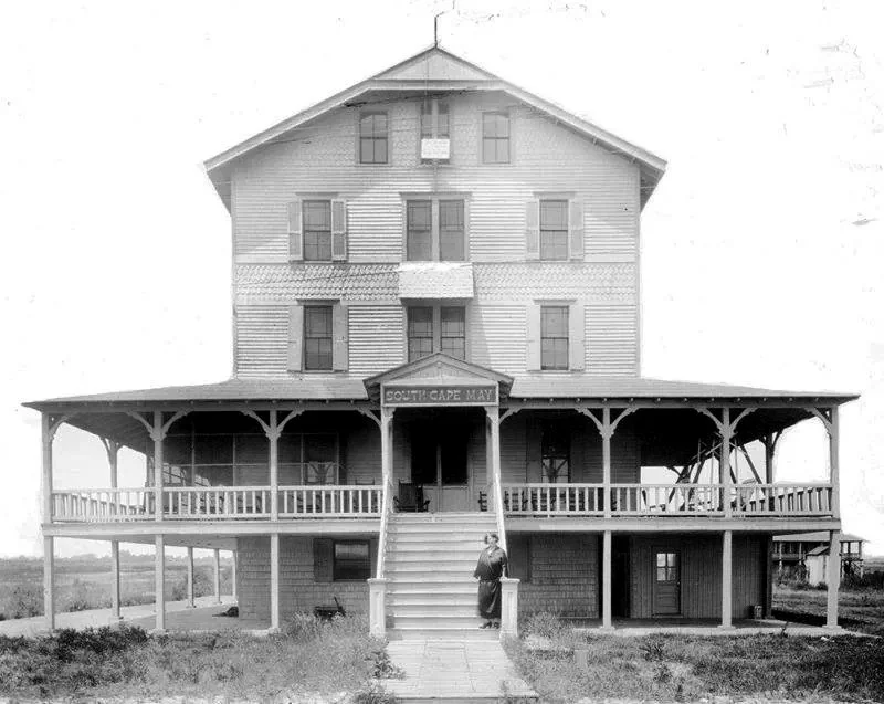
A South Cape May cottage before Mother Nature finally erased the borough from the map after storms had caused major damage over the years. Today, the land is owned by The Nature Conservancy.
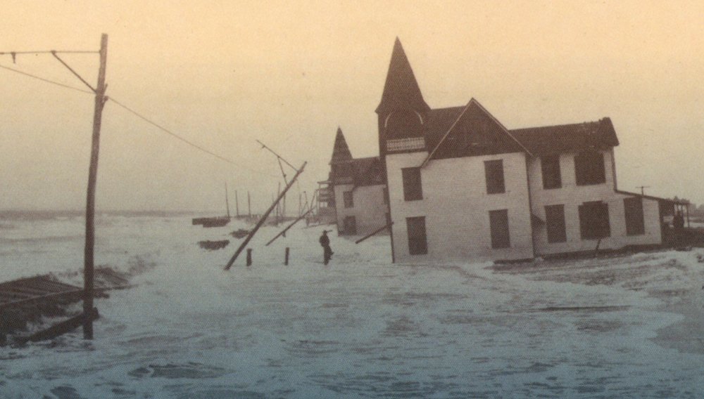
This image from 1944 shows a storm surge overtaking South Cape May, eventually wiping out the borough.
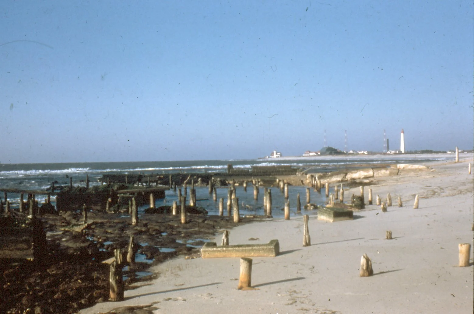
Remains of South Cape May after the Great Atlantic Storm of 1944.